Over the Thanksgiving holiday my family and I took a road trip to Monument Valley and Canyon de Chelly. I wanted to be in wide open spaces with spotty cell-phone coverage, travel on roads the GPS couldn’t find, and see stunning natural beauty and ancient cliff dwellings.
I scored on three out of four: sadly, cell phone coverage
was pretty consistent throughout the trip.
Day One - Las Vegas to Chinle
The route: I15 north to 9 in Utah, then across a series of smaller roads eastward. In Kayenta, Arizona, we picked up 163 to Monument Valley proper. At the
visitor center we took the scenic dirt road through the valley at sunset for as
long as we could see it in the fading light. After leaving the visitor center,
we turned back on 163 and followed it to 191, where we headed southward to
Chinle.
Total miles: approximately 439
Hours on the road: 10
We planned this trip along the most scenic route we could take,
given our time constraints. You could easily spend a week or two
(or more) along the route we traveled, if you took the time to explore
the side trips in the region.
We, however, had a limited amount of time to get from Vegas
to Chinle, and our biggest desire for the first day was to see Monument Valley.
The last time I’d been there, it was still a remote place,
easy to spot from the highway because there weren’t many roads or buildings.
This time, the presence of people was apparent. It’s not visited
on the same scale as the Grand Canyon’s South Rim or Yosemite, but a lot of people
are finding their way to this magnificent place. Adjacent to the visitor center
there’s even a hotel, The View Hotel, which gives guests a sweeping view of the
famous valley.

“When you said we’d see ‘rock formations,’ you didn’t say
anything about the size,” my son said as we gazed at Monument Valley’s
distinctive buttes, spires, and mesas.

The light here is stunning against the towering rocks,
especially at sunset with the advancing shadows adding an intense contrast in
colors. After the sun set, the sky gave us a ribbon of pink and blue on the
horizon as a backdrop to the red rock spires, which held onto their distinctive
colors well after the sun was down.

After Monument Valley, we hit the road to Chinle, (shin-lay)
and were soon enveloped in total darkness. We could almost see the Milky Way
from the tinted windows of the car, but we couldn’t see anything else. I’d love
to drive this road during the daylight to see what else this area holds.
Day Two: Chinle to Flagstaff
The route: In Chinle, we traveled both the North Rim Drive
and South Rim Drive to each of the ten overlooks of Canyon de Chelly National
Monument. We then backtracked to 191, and connected with 264 west into Tuba
City, picking up a short stretch of 160 before turning southward toward
Flagstaff along 89.
Miles: 237, plus 71 miles in Canyon de Chelly
Hours exploring and on the road: approximately 9
In the morning we watched the cows grazing in the field
adjacent to our hotel as we loaded up the car. The rooms at the Holiday Inn were
wonderfully comfortable and clean, and the entrance to Canyon de Chelly was so
close we almost could have walked there.

The restaurant at the hotel had as many locals in the early
morning as tourists. The gift shop had a full display of Tony Hillerman books,
and at breakfast I spotted one tourist avidly reading one of the author’s
popular detective novels set in the Navajo Nation and surrounding areas.
After breakfast we headed directly to Canyon de Chelly. Our
first stop was at the visitor center, where we verified the pronunciation of
the name: Canyon de “Shay,” not “Shelly.” I picked up a map and NPS guide before we set off to explore both rims of the Monument, which encompasses both Canyon
de Chelly and Canyon del Muerto.
The Navajo still live here, both along the rims and in the
canyon. Traditional hogans are a common sight, and many roads are marked as
private. Visitors need to be respectful of the fact that these aren’t all
public lands--this is home to many families.
To enter the canyon floor, you must have an authorized
guide, unless you hike down into the canyon along the White House Trail, which
starts at White House Overlook and leads to one of the ruins. It’s a 2.5 mile hike, 600 feet down and back along switchbacks, and takes about two hours round
trip.
Our first look at Canyon de Chelly was at the Tunnel
Overlook, where a man was selling hand-made wares from his car, a common sight
in this region. The path down to the viewing platform is steep, and my husband
chose to skip it and chat with the artist while I inspected the view. The
canyon’s not so deep here, close to its mouth, but eventually attains a depth
of about 1,000 feet.

The depth and majesty of
the canyon starts to show at Tsegi Overlook. This was where I began saying, frequently, “Please
step back from the edge of the canyon,” or some variation thereof. (Also spoken
often: “No, not funny. Not funny at all.”)

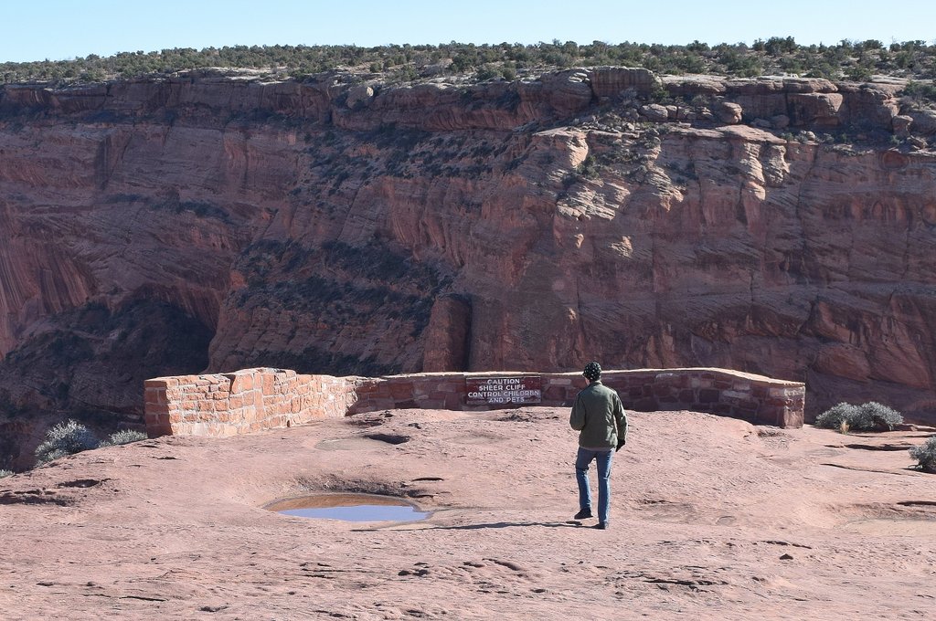
“That’s a lot of down,” my son observed, peering down. You
will not find an abundance of rails or walls here to keep you from exploring right
up to the edge of the cliffs. Posted signs warn you to keep your kids and pets
under control, but sheer drop-offs are everywhere. It’s a little scary and one
of my favorite parts of tribal lands in the Southwest.
Each overlook provided a new and stunning view into the
valley below, where ancient ruins exist next to small farms and stands of trees.
The day was icy cold and clear, with ravens and hawks soaring above and below us,
taunting me to take their pictures.


The history of the canyon is long, and some of it is quite
sobering. It’s been inhabited for 5,000 years, including the years during which
we waged war on the Native Americans. According to the informational pamphlet: “In
1863, Col. Kit Carson began a brutal campaign against the Navajo. In the winter
of 1864 Carson’s troops entered the eastern end of Canyon de Chelly and pushed
the Navajo toward the canyon mouth. Resistance proved futile; most Navajo were
captured or killed. Carson’s forces returned in the spring.... They destroyed
the remaining hogans and orchards, and killed the sheep.”
This happened during the Long Walk, the forced
300-mile march of Navajos to Fort Sumner in New Mexico. The forced walk and subsequent
internment resulted in the loss of thousands of Navajo lives. After four years
of exile, the remaining Navajo were allowed to return to their homeland. When
you know the history, it’s hard to forget when exploring the canyon.
We left Canyon de Chelly late in the afternoon and headed
toward Flagstaff. Instead of dropping down to I40, we took 264 across Navajo
and Hopi land. We saw huge expanses of country filled with mesas and rock
formations. Homesteads dotted the landscape, where cattle, sheep, and horses
grazed. Few other vehicles were on the road, mostly pick-up trucks.
After the sun had set in a spectacular blaze of orange and
gold in a cloudless sky, we turned southward toward Flagstaff. As we started to
climb into the mountains, we pulled over and took a few moments in the 28
degree weather to stare at the night sky, filled with stars and a fabulously
visible Milky Way. It had been years since I’d seen the Milky Way. In Las Vegas,
light pollution has bleached the stars from the sky.
We talked about going to the Lowell Observatory in Flagstaff,
but after we checked into the hotel, got lost (twice) trying to find a
restaurant, and finally had dinner at the retro Galaxy Diner, it was too late.
Something for the “next time” list.
Day Three: Flagstaff to Las Vegas
The route: I40 to just past Ash Fork, where we picked up Route 66,
which we took into Kingman. Then we grabbed 93 home to Las Vegas.
Miles: 266
Hours on the road: 5
By day three, we were all ready to get home. No matter how
much spectacular scenery we’d seen, everyone was ready to be out of the car.
First stop: Matador Coffee, the coffee shop we’d driven past
several times while we were lost the night before. It’s a little local place in
a remodeled car repair garage. The food and coffee were great, but the only
downside was that we wound up eating in the car. There wasn’t much seating and
not much (if anything) in the way of heating, and it was about 27 degrees out. I
noticed the temperature didn’t deter the line of bundled-up people waiting for
coffee and food.
We headed out of Flagstaff west on I40 until we grabbed an
exit onto Historic Route 66. The old road runs in a semi-circle, roughly parallel to I40 from
around Ash Fork all the way into Kingman. Beyond that, you can continue on into
Oatman and all the way to Topock, and in California the road picks up again
just off I40 along the Mojave Preserve’s southern border.
We were only going as far as Kingman, with one stop at the Hackberry General Store.
As Route 66 unfurled in front of us, I saw dozens of places
ripe for photographs: ruins, horses, memorabilia shops, and kitsch galore...
more stops for the “later” list.
I’ve stopped in Hackberry many times over the years, and
it’s always a fun place to photograph. This time was no different. Loads of
vintage cars and Route 66 memorabilia fill the grounds. It’s hard to resist
buying a souvenir here.

After our short stop, it was only about two hours
until we pulled into our driveway. That’s the moment we enjoyed one of the best
parts about any trip: getting home.
Additional reading and notes on the route:
I’ve collected some example of possible side trips off our
route, but be forewarned: adventurers will find many more places to explore in
this region. Remember to take all appropriate travel precautions and consult an
actual map, not just your GPS, when you’re in remote areas. Here are some
possibilities: Zion, Cedar Breaks National Monument, all Rims (North, South,
and West) of the Grand Canyon, Bryce Canyon, Grand Staircase Escalante National Monument, Vermillion Cliffs National Monument, Valley of the Gods, Petrified Forest, Sedona, Montezuma’s Castle National Monument, Jerome, Oatman, and the
Mojave National Preserve.
On the history of Canyon de Chelly and the Navajo:
I found this account of the Long Walk as related by Navajo
elders. It includes the story of Fortress Rock, where the Navajos who refused
to surrender hid atop the rock and outlasted the troops who had been left to wait them out,
presuming the Navajo would run out of food or water.
The Navajo did run out of water, but waited until nightfall
on a full moon to create a human chain down the rock to a water source,
silently collecting and passing water up the chain of people. Although the holdouts
outlasted the troops, they were also eventually captured and forced on the Long
Walk.
I first read about the history of the canyon and the Long
Walk in Bury My Heart at Wounded Knee,
which devotes a chapter to it.
If you’ve been into any of these areas, what are your
favorite places?
_____
All pictures by Terrisa Meeks. See more from this trip on flickr.
_____
All pictures by Terrisa Meeks. See more from this trip on flickr.