Showing posts with label Mojave National Preserve. Show all posts

Friday, September 25, 2020

Fire in the Desert

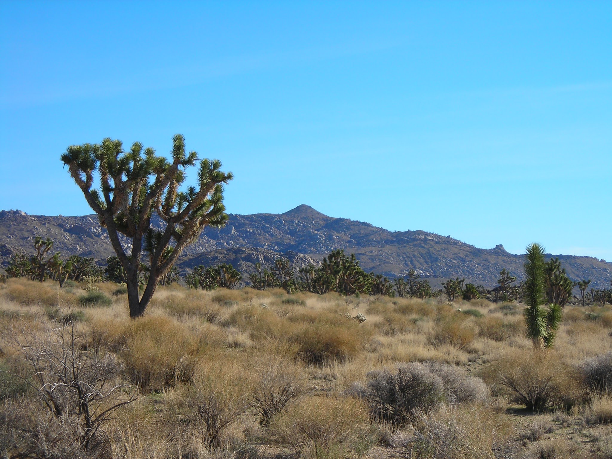
The Dome Fire in the Mojave National Preserve destroyed about a quarter of one of the world’s largest Joshua Tree forests.


It’s a place I know well.


During a year when fire is tearing through so much of the western United States, destroying entire towns and killing people, the Dome Fire in the MNP last month probably didn’t spend much time on most people’s news radar.

For those of us with a personal connection to this part of the Mojave, the news of the fire has been heartbreaking in a very specific way. Desert rats understand that the desert is not adapted to fire. We know that the invasive grass species that have permeated our deserts act like tinder, allowing fire to spread and grow into conflagrations that can permanently alter the landscape. Native plants are destroyed and invasive species can easily take over.

This is such a large topic that I’ve spent the last month reading articles about fire in the desert, delving into academic studies and news articles, including accounts of the Hackberry Fire of 2005, which took out over 70,000 acres in the MNP. I’m mildly obsessed at this point, especially knowing that many non-desert dwellers consider the desert to be full of nothing but dirt and rocks, a terrible misconception that leads the uninformed to think of the desert as empty.

Mojave National Preserve

Mojave National Preserve

Mojave National Preserve ca 2006

One of the first articles I wrote as a travel writer was about the Mojave National Preserve. I can still remember the excitement of leaving the pavement and turning onto a dirt road I hadn’t previously explored, Joshua trees everywhere, the wide-open desert stretching out in every direction. I15 was a far-off ribbon of movement in an otherwise vast wilderness. 

In 2008, my family spent Thanksgiving vacation wandering around the Mojave, through the MNP, Afton Canyon, and Joshua Tree National Park. Winter is the best time to visit the desert. In the MNP, we found an abandoned mine, windmills, old corrals, and miles of desert filled with Joshua trees, cacti, lava fields, sand dunes, and desert shrubs.

Mojave National Preserve

Mojave National Preserve

Deserts are fragile, contrary to their dirt-and-rocks image, and are full of life. As one article I recently read pointed out, even the soil is alive in the desert. 

The desert is an easily misunderstood place. It’s harsh and dry and prone to extreme temperatures. Both the plants and the animals can be prickly and unfriendly. Fire may not seem like a big deal in such a place, but I’m here to tell you that’s simply not true. 


All photos by Terrisa Meeks


Sunday, November 15, 2015

In the Badlands of the Tule Springs Fossil Beds National Monument


The Monument is an interesting place, whether you see fossils or not.


In the days before Las Vegas swallowed a large patch of the Mojave Desert, you could see Tule Springs as you approached from US95. It was a distinct patch of green in the middle of the desert. When I was growing up, the park and its historic buildings were popular for school field trips. I remember the extensive badlands all around Tule Springs Park, which is officially known today as Floyd Lamb at Tule Springs.

Tule Springs, however, isn't just the park—the name encompasses the larger area, which in ancient times was a marshy place that attracted late Pleistocene Era mammoths, camels, horses, and bison. Now, Tule Springs includes the fossil beds holding remnants of those creatures and the Upper Las Vegas Wash. In Vegas' boom years, parts of the badlands were lost to development, and the land that’s now protected as a national monument was nearly sold for development in 2003. Thanks to the hard work of many dedicated people over the course of several years, the new Tule Springs Fossil BedsNational Monument now protects over 22,000 acres of this fossil-rich, undeveloped desert.

I set off to find a way into the Monument close to Tule Springs Park and wound up at the end of Durango, where the street dead ends into an access point into the Monument.

Here’s the thing: this is a brand-new Monument—the newest in the United States—and if you’re expecting a visitor’s center and kiosks and a interpretive trail with a bunch of neatly labeled fossils, you’re going to be disappointed.

In my opinion, this lack of development is a major bonus.

If you like exploring wild, untamed places, you’ll find plenty of things to appreciate in the Fossil Beds. Before you get into the more untouched sections, you’ll find evidence of the area’s former life—shotgun shells, ATV tracks, trash. Beyond that, the Upper Las Vegas Wash is as wild as it can be.

The Monument is long, skinny piece of land, running somewhat parallel to US 95 for several miles and wrapping around Tule Springs Park. It’s full of Ice Age fossils, which scientists have known about since the 1930s.

I wasn’t expecting to see tusks sticking out of the ground… at least, not in the area closest to the parking lot. I did think that I’d be able to identify some fossils, but although I picked up several interesting rocks and closely examined the badlands, I was never able to identify a fossil.

(Later, in speaking with Jill DeStefano, President of the Protectors of Tule Springs, I learned that I had probably walked right over and past all kinds of fossils without knowing it. Learning to identify fossils takes some training, she explained. You can sign up with the PTS for tours, if you'd like some guidance.)

Although I may not have found any fossils, I found a landscape that made me think of the Mojave Phone Booth.

If you’ve never heard of this cult landmark, it’s exactly what it sounds like: a functioning phone booth that was out in the middle of nowhere, in what is now the Mojave National Preserve. People from all over the world trekked to the booth to answer the calls that came in from other people all around the world. Until the Park Service decided it needed to be removed, and then the odd attraction was gone.

But although that single attraction is gone, if you wander the Mojave you’ll still find deserted and abandoned mines, ranches, homes, and other eerie bits of evidence about the former inhabitants of the area.

The fossil beds are like that.

Why? Let me explain what we found on the day we explored.

Two Descansos

I’ll admit I have a fascination with roadside memorials, also known as descansos, although I’m rarely in a spot to get out and read memorials. The larger memorial closest to the access point on North Durango looks like it’s been there a while, but the smaller one atop the hill appears to be about a year old.  

Right next to the big descanso, we found…

The Stove Shrine

At first, we thought the metal parts on the ground were pieces of a car. Then we found that it was a stove that looked like it had been blown up. Then we found…. Stove Shrine.

“There’s like a bag of something inside,” my son said, peering under the dome of plastic.

“Don’t touch it,” I said.

“Don’t worry,” he replied. “That’s creepy.”

The Badlands... or, “Where are the fossils?”

“Is this a fossil?” was the most common thing we said to each other during the first 45 minutes of our hike, usually followed by, “Well, if it’s not a fossil, what kind of rock is that?”


Our preoccupation with fossils soon gave way to a general fascination with the badlands, which are littered with the remnants of their former life as a free-for-all area for shooting and ATV riding.

As we turned the corner around the first set of badlands, I saw someone had put up a rock labyrinth. We sighted in on the furthest badlands we could see, setting out across…

The Upper Las Vegas Wash

It’s big. It’s wide. It’s without any kind of trails, and it had obviously just been full of water not long before because the ground was still wet in places and we found plenty of puddles.

There were no tracks, no trails, and no people. The only thing north of us was open desert. The badlands behind us hid most of the houses. To the west, we could see the peak of Mt. Charleston, and to the east we could see the shooting complex.

The creation of the Monument protected the Upper Las Vegas Wash as well as the fossil beds. The Upper Wash is part of the valley’s watershed and drains into Lake Mead. It’s home to jackrabbits (we startled a large one), all manner of birds (including burrowing owls, which we didn’t see), tortoises, and rare desert plants like the Las Vegas bear poppy.

My son and I clambered up and down the uneven ground of the Wash, an area that I would have been nervous about venturing into had there been even the hint of a cloud anywhere in the distant western sky. It’s a mammoth (no pun intended) stretch of Wash, and evidence of the water that had just swept through (during some of the same storms that flooded Scotty’s Castle inDeath Valley) was everywhere.

After crossing the Wash and examining more badlands for fossils, we turned and headed back to the trail head.

The Weather Balloon

At first we thought we’d found a hunting snare, but we traced the string to a weather balloon, which made both of us giddy with excitement. My son was delighted to note that a handle was included for easy carrying.

(Naturally, we returned the balloon back to NOAA with pictures of where we found it.)

The Mussel Shells

“Are those oysters?”

“Yep, and clams.”

We were both baffled. We looked around for anything that would indicate someone had camped in the vicinity because there was a large pile of oyster and clam shells, all of which looked very modern--not to mention the broken porcelain bowls. It was a huge pile of shells. We never found a good explanation.

The Upside-down Truck Cab

…but only the truck cab, no bed, with a pile of new-looking women’s clothing next to it. I stayed on top of the Badlands while my son explored the weird scene. We again looked for anything that would look like someone had been camping/squatting, but found nothing.

It’s easy to get lost in the badlands, and we climbed atop them twice to make sure we had our bearings when we were heading back to the car.

In most badlands, you’re contending with ATVs, but here you’re free to explore without being run over. I was a little worried about the obvious evidence of illegal shooting, but never heard shots nearby or saw anyone shooting.

Groups like the Protectors of Tule Springs are doing their best to help keep the area cleaned up, to install signs, and to help educate people about the importance of the area. It’s a precious repository of Ice Age fossils and an important swath of desert that was (thankfully) saved from being sold and developed into more houses. Get out there and enjoy it before it becomes tamed.

There are several points where you can access the Monument; one of the most popular is actually at the far north end of Decatur, the site of the “Big Dig” where heavy equipment was brought in to excavate trenches in the 1960s.

Have you been to the new Monument? Or have you ever found a fossil while out exploring? If you have, leave some comments!
________________
All pictures by Terrisa H. Meeks


Saturday, January 12, 2013

Las Vegas Day Trips & Staycations


Despite the ridiculously cold weather here in Las Vegas (38 degrees at 10:30 a.m.… seriously?), I was out and about today. I gave a talk at the Summerlin Library about Las Vegas Day Trips and Staycations—one of my favorite topics.

Luckily, I had my husband with me, because later on—on the drive to lunch at Due Forni—I got to ask him, “Did I mention that Death Valley is the largest National Park in the Lower 48?”

“No,” he said, "You missed that," which opened the door for us to talk about all those little details that I had intended to share, but had missed during my talk. What can I say? So many fabulous places to describe, so little time.

If you were at the talk today, here are some extra details, along with links to the official sites for all the places I talked about. And if you weren’t at the talk, well, just imagine a slightly out-of-breath woman is reading the text to you, and it will be kind of like you were there.

In the late 1970s, the BLM issued permits for oil drilling in Red Rock, but fortunately that idea was squashed.


The Park hosts Civil War reenactments every year for Nevada Day, and throughout the year they regularly hold living history and pioneer events. (Interesting side note: Since our State Day is October 31, I grew up thinking Halloween was a holiday. One of the many oddities of being raised in Las Vegas.)


Twenty-four of Ash Meadows’ plants and animals can be found nowhere else on earth, giving Ash Meadows the highest concentration of endemic life in any local area in the United States.


Experts now say that St. Thomas, the town that was under Lake Mead for over 60 years, is not expected to ever be underwater again.


Grafton was part of what was known as the Mormon Cotton Mission, an unsuccessful attempt at cotton farming along the Virgin River. 


Okay, you already know that it’s the largest national park outside of Alaska. But did you know that the famous Harmony Borax Works were only open for 5 years?


Curtis Howe Springer named his spa Zzyzx because he wanted it to be “the last word” in health (which might have been really catchy, except that he was a fraud.)

Links to information about the other places I talked about today:

Lake Las Vegas hotels: Ravella, Westin, Aston MonteLago

How many of these places have you visited?

Many thanks to the library and everyone who came to my presentation!

All pictures by Terrisa Meeks

Friday, January 09, 2009

The Kelso Sand Dunes

A few months ago, I got an e-mail from a gal who was wondering if she could hike at the Dumont Sand Dunes. No. It’s an ATV area (aka OHV Area), which is great if you like quads and sand rails, but it’s not a place to do any hiking. Fortunately, Dumont is only one set of sand dunes in the vicinity of Las Vegas. If you’d rather hike the dunes than ride over them, head south from Dumont into the Mojave National Preserve and check out the Kelso Sand Dunes.

In the summer months, Kelso is too hot to explore, but from about November through May, hikers can explore sand dunes that are closed to off-road vehicles. The hike to the top of the 700-foot sand dunes is one of my favorite hikes because you can slide down the face of the dunes when you start your journey back to the car. If you’re lucky, you’ll hear the dunes “booming.” Kelso is one of only 30 sand dunes world-wide that create this rumbling vibration that you can hear and feel.

Last spring I saw the Kelso Dunes in bloom, right at sunset. The evening primrose perfumed the air, and the afternoon light put shadows on the dunes’ faces. While the other desert flowers were closing, the primrose covered the ground in big white blossoms.

Photo Information: My pictures at the Kelso Sand Dunes in April 2008.

Saturday, January 03, 2009

Zzyzx: The Spa in the Mojave

When the Mojave National Preserve was created in 1994, I remember being a little unsure about what, exactly, we were preserving. (This was before I discovered the MNP.) Then the urban landscape overtook the desert around Las Vegas. I’m glad now that something was set aside before the entire Mojave Desert was covered in Wal-Marts and tract homes.

Last year, my family visited Zzyzx. Today it’s home to a desert research group, but the remains of the former spa built by Curtis Howe Springer still stand. In 1944, Springer filed a mining claim on the land and proceeded to build several buildings, including a spa and hotel. The only problem was that the land was never officially his. The BLM took the property back in 1974.

The abandoned buildings on the edge of the dry Soda Lake are slowly being claimed by the desert. A boat embedded between two palms sits next to the horseshoe pit. The vast dry lake bed sits white and flat for miles, just beyond a spring-fed pond ringed with palms. The old spa’s outdoor pools still hold water. Through windowpanes without walls, the Providence Mountains rise in the background.

This was my favorite photo trip from 2008, but the pictures were never posted because about ten days after these pictures were taken in April, my mother got very ill; on May 6, she passed away. On this particular day, however, my only concern was how to find the best photograph on a beautiful spring day.
____________
Photo Information: My photographs of Zzyzx.

Saturday, December 13, 2008

Four Wheel Drive Recommended


If you’re an off-road enthusiast, Southern California abounds with OHV (Off Highway Vehicles) areas, many of them a short drive from Las Vegas. Over the Thanksgiving holiday, we stayed on the ouskirts of Barstow and discovered the Stoddard Valley OHV Recreation Area. The area held several campsites, but certainly not so many people that you’d have a problem finding a spot to camp and/or ride your ATV. Several riders were staying at the Holiday Inn on Lenwood, a nice hotel that we enjoyed. It sits right on the edge of Stoddard Valley, right next to an outlet mall and a Hampton Inn.

My husband told me he wanted some dirt roads on this trip, so the detail map and I got friendly. For our ride home, I found a couple of detours to take us around I15 through country we’d never explored.

Our first detour was into the Afton Canyon Wilderness. The dirt road winds through the canyon. Shortly after we took the turnoff from I15, we stopped at the Afton Canyon Campground and watched a train passing. The railroad runs through the canyon, as does the Mojave River. ATVers are thick here, which was a good thing because we had plenty of tracks to follow through the river bed. My 4-wheel-drive-loving husband was in heaven, slinging mud all over his beloved truck. The muddy, bumpy, fun ride through the canyon didn’t allow for pictures.

We hopped back on I15 for about 10 miles to Kelbaker Road in Baker, where we exited into the Mojave National Preserve. We were in search of a lava tube. I knew it was off Aiken Mine Road, but I didn’t know its exact location. It’s one of the places in the Mojave NP I haven’t been. We didn’t find the lava tube, but we did find the abandoned Aiken Mine. Volcanic rock appeared to be the former mine’s product. Derelict equipment and buildings are scattered over the top and side of a cinder dome. Various grades of volcanic rock and tailings are piled everywhere. It’s all equipment my husband knows well, so he showed my son around and explained what each part of the operation did. After we left the mine, corrals and windmills appeared periodically along the dirt road. Somewhere out there, the Mojave Phone Booth used to stand, attracting a cult following before it was removed.

I planned on taking Aiken Mine Road all the way to Cima Road, but we wound up on a different road. Not many street signs exist out there. I wasn't really sure how we came to be on the sandy, northbound power-line road, but at least it looked well-traveled. The compass told us we were heading in the right direction before we could see the cars and trucks of I15 in the distance. As we neared Cima Road, we found an abandoned ranch. Vandals had scratched the year off the name and date inscribed in the concrete by the corral. My husband looked in the window of one of the abandoned buildings and saw a stack of magazines that he described as “Nothing anyone should look at. Not even me,” so we knew we had to be close to the main road. Softball-sized gourds dotted the ground under the Joshua trees.

Once we arrived at the Cima Road entrance to I15, we applauded ourselves for our navigational skills. We joined the cars heading home to Las Vegas and watched the dense line of cars snaking its way in the other direction, toward Los Angeles. How many of them have any idea what the desert beyond the highway holds?
_____________
Photo information, top to bottom, all my photos: Abandonded ranch near Cima exit; Joshua tree with gourds growing under it; abandonded mining equipment; the view into Afton Canyon; the railroad bridge.